


Update: January 23, 2025
The Hughes Fire ignited near Castaic Lake, which is near Santa Clarita, in northern Los Angeles County. The wildfire started on January 22, 2025, around 10:50 a.m. PST.
This new wildfire was fueled by strong Santa Ana winds with gusts up to 65 mph and extremely dry conditions. Within less than 24 hours, the fire expanded from 50 acres to over 10,000 acres, prompting mandatory evacuations for approximately 31,000 residents. As of Thursday morning, the fire is 14% contained.
Meanwhile, firefighters made significant progress on containment of the Palisades Fire and Eaton Fire. Both wildfires are now over 70% contained.
Current fire size and containment statistics
- Palisades fire:
- 23,713 acres burned
- 72% containment
- Eaton fire:
- 14,117 acres burned
- 95% containment
- Hughes fire:
- 10,176 acres burned
- 14% containment
The Cotality Hazard HQ Team will continue to monitor the Southern California fires and provide updates when available.
Update: January 22, 2025
The Palisades and Eaton Fires are having a significant impact on communities across Los Angeles, leaving many displaced and causing widespread property damage. The magnitude of the impact may lead to substantial financial strain on insurers they face an influx of claims.
As of Jan. 17, there were approximately 20,000 properties within the perimeters of the Palisades and Eaton Fires, combined.
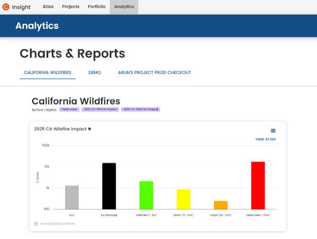
The Cotality Insight platform shows users a detailed, property-specific view of the wildfire’s impact allowing them to make data-driven decisions. Here’s how Cotality Insight can help:
Visualizing property damage
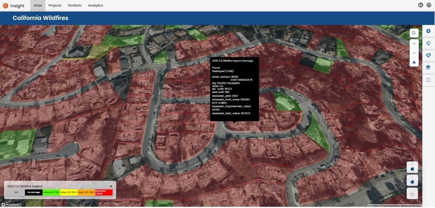
- Assessing extent of damage: Users of the Cotality Insight platform can visualize properties categorized by the extent of damage: destroyed, damaged, affected, or unharmed. Leveraging data from trusted sources like Vexcel Imagery, FEMA damage inspections, and CAL Fire damage inspections, the platform provides precise insights into a wildfire’s impact.
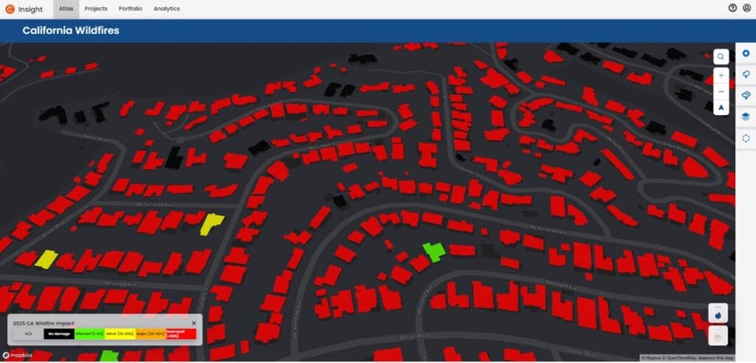
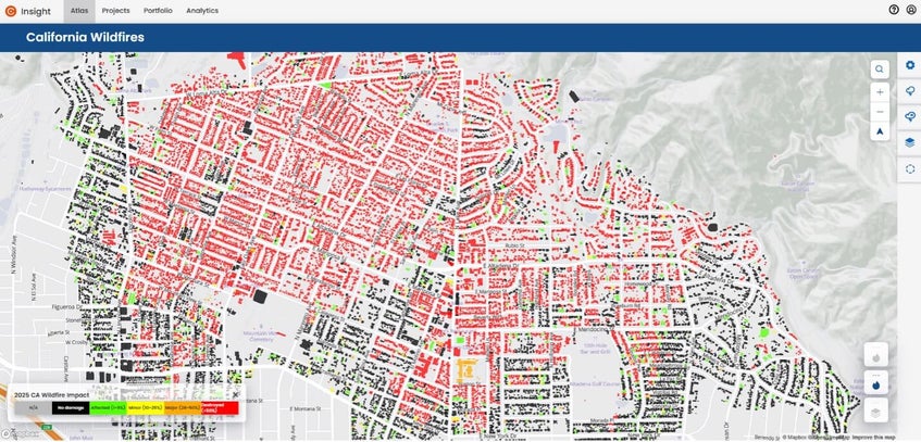
- Detailed aerial imagery: Insight’s integration with aerial imagery from Vexcel allows users to visualize the damage extent at each affected property. This high-resolution imagery offers a clear view of destruction, enabling a granular analysis of affected regions.
Portfolio-specific insights
For insurers managing a portfolio of locations, Insight provides the following capabilities:
- Portfolio damage inspection: Upload your portfolio to visually inspect the damage at each covered location.
- Damage quantification report: Generate detailed reports quantifying the number and value of policies by degree of damage. These insights help prioritize response efforts and streamline claims processing.
Empowering insurers with wildfire insights
Insurance carriers using Cotality Insight gain significant advantages. The platform enables precision in identifying affected policyholders, allowing carriers to quickly assess impacted properties within fire perimeters. It enables comprehensive financial exposure analysis by comparing their portfolio against property-specific damage assessments and associated total reconstruction costs. Additionally, Insight enhances claims processing by expediting claims through efficient resource allocation and proactive communication with policyholders. Finally, it supports regulatory compliance, helping insurers meet requirements for timely and accurate reporting during disaster events.
By leveraging Cotality Insight, insurers can navigate the challenges of California’s wildfire season with confidence. This platform not only empowers insurers to respond more effectively but also enhances resilience and recovery for affected communities.
Status update on fires
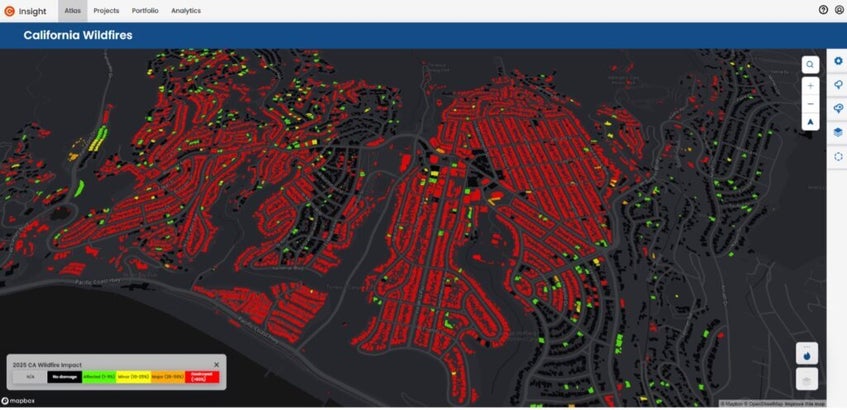
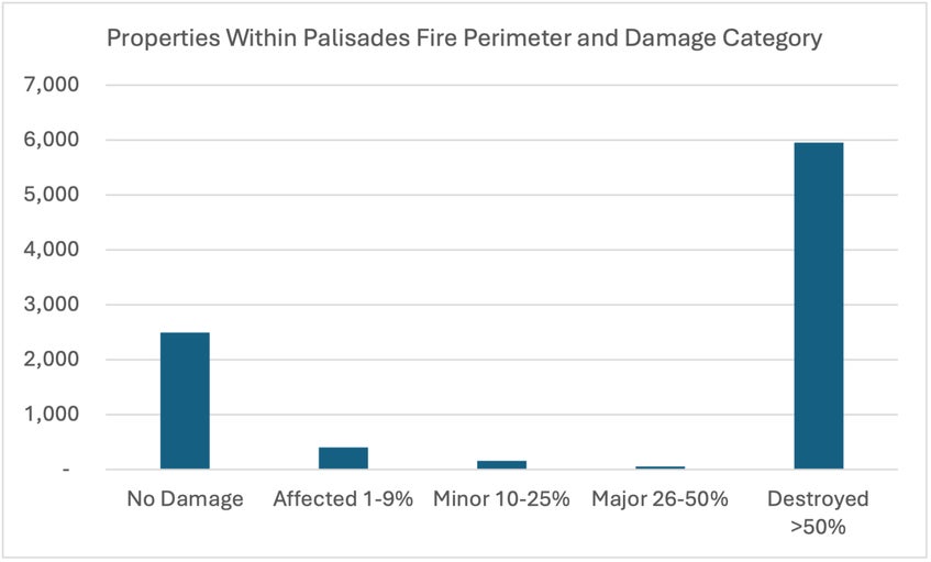
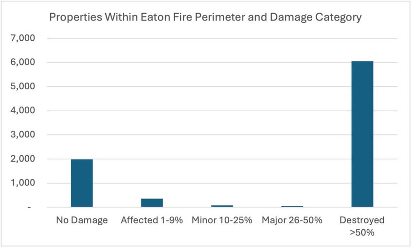
Cotality Insight provides detailed figures on the number of properties impacted within each fire perimeter by degree of damage (Figures 6 and 7).
As of Jan. 17, around 12,000 of the approximately 20,000 properties within the perimeters of the Palisades and Eaton Fires are categorized as destroyed, meaning damage is greater than 50% of the structure. Figures 6 and 7 do not include properties that have not yet been inspected for damage.
Firefighters have made significant progress with containment, and the Palisades Fire and Eaton Fire are now both over 60% contained.
Current fire size and containment statistics
- Palisades fire:
- 23, 713 acres burned
- 63% containment
- Eaton fire:
- 14,117 acres burned
- 89% containment
The Cotality Hazard HQ Team will continue to monitor the Southern California fires and provide updates when available.
Update: January 16, 2025
Cotality estimates the Eaton and Palisades Fires are causing devastating initial residential and commercial property losses estimated to be between $35 billion and $45 billion.
Containment for both of these Los Angeles wildfires is improving but still limited. On the afternoon of January 16, 2025, both fires are less than 60% contained. Cotality will provide final insured loss estimates once the fires have been fully contained.
Fire weather concerns are easing for the rest of the week as winds die down, offering a much-needed reprieve from recent hazardous conditions. However, the outlook for next week is more concerning as Santa Ana winds are expected to return.
Current fire size and containment statistics
- Palisades fire:
- 23,713 acres burned
- 22% containment
- Eaton fire:
- 14,117 acres burned
- 55% containment
- Hurst fire:
- 831 acres burned
- 98% containment
The Cotality Hazard HQ Team will continue to monitor the Southern California fires and provide updates when available.
Update: January 14, 2025
Massive wildfires continue to rage in the Los Angeles metropolitan area as firefighters work tirelessly to contain the flames. Over 100,000 people have been evacuated.
Santa Ana winds, which have accelerated the spread of these wildfires, are forecasted to persist through Wednesday. While wind speeds are anticipated to be lower than those experienced last week, vegetation remains extremely dry and is highly susceptible to fire.
Current fire Size and containment statistics
- Palisades fire:
- 23,713 acres burned
- 17% containment
- Eaton fire:
- 14,117 acres burned
- 35% containment
- Hurst fire:
- 831 acres burned
- 97% containment
Properties and reconstruction cost value within fire perimeters
As of January 10, approximately 11,838 properties fell within all identified fire perimeters, with an estimated total reconstruction cost of $10 billion.
As of January 13, an estimated 16,636 properties lie within the fire perimeters of the Eaton and Palisades Fires, with a total reconstruction cost of $13.1 billion.
Note that not all properties within the fire perimeter are necessarily damaged by fire. Additionally, properties that are impacted may not have sustained damage equal to their full reconstruction cost value.
The Cotality Hazard HQ Team will continue to monitor the Southern California fires and provide updates when available.
Update: January 10, 2025
Firefighters continue to battle the massive wildfires in the Los Angeles metropolitan area. The situation is rapidly evolving.
- Palisades fire
- 20,438 aces burned
- 8% containment
- Over 11,000 structures within the perimeter
- Eaton fire
- 13,956 acres burned
- 3% containment
- Over 12,000 structures within the perimeter
- Hurst Fire
- 831 acres burned
- 37% containment
- Lidia fire
- 395 acres burned
- 75% containment
- Kenneth fire
- 1,000 acres burned
- 35% containment
The red flag warning in the area is scheduled to expire on January 10, 2025, at 6 p.m. PST. Light winds are forecast for Saturday. However, strong Santa Ana winds may develop Sunday evening, and Santa Ana conditions are anticipated to return next week.
The Cotality Hazard HQ Team will continue to monitor the southern California fires. Updates, including the number of properties and reconstruction value within the fire perimeters and damage estimates, may be provided when the full extent of impact is available.
Update: January 9, 2025
The wildfires in California have rapidly expanded. The Palisades Fire has currently burned 17,236 acres and has quickly become one of the most destructive wildfire events in the history of Los Angeles. While the Woolsey Fire of 2018 was the most destructive in Los Angeles history, the Palisades Fire may exceed its level of destruction.
Cotality estimates at least 9,900 structures are within the fire perimeter, and that estimate is likely to grow as the fire perimeter continues to expand. The fire remains at 0% containment.
The Eaton Fire is now at 10,600 acres. Cotality estimates that at least 11,700 structures are within the perimeter, and this estimate is likely to increase as well. This fire also remains at 0% containment. The Hurst Fire’s damage currently stands at 855 acres, but it is at 10% containment.
It is important to note the incredibly fluid nature of the current situation. Without any containment and the continued presence of high winds, it is very challenging to estimate the number of structures within the wildfire perimeter.
At 2 a.m. PST, the Palisades Fire was at 2,920 acres, and there were at least 1,600 structures within this area. By 1:17 p.m. PST, the fire had expanded to 15,832 acres, encircling at least 9,700 structures within this perimeter. Cotality estimates that over 70% of buildings in the affected area were built before 1985. These older structures are more vulnerable to damage.
Red flag warnings continue to remain in effect over all affected areas. Winds may decrease slightly this afternoon to aid in suppression efforts, but gusts may still approach 60 mph in some areas and extreme fire behavior is still possible. Another round of Santa Ana winds is forecast from this evening until Friday morning. Forecasts show strong north to northeast Santa Ana winds of 30–40 mph with the possibility of gusts up to 70 mph.
Relative humidity is expected to drop to single digits (8–15%) today and Friday to further exacerbate fire conditions. Extremely dry fuels combined with strong winds and low humidity create conditions for rapid fire spread with limited to no suppression capability.
The Cotality Hazard HQ Team will continue to monitor the Southern California fires. Updates, including the number of properties, the reconstruction value within the fire perimeters, and damage estimates, may be provided when the full extent of impact is more known.
Update: January 8, 2025
The Palisades Fire began on Jan. 7 at approximately 10:30 a.m. PST in Pacific Palisades, California. Fueled by winds reaching speeds of at least 40 mph, the fire rapidly consumed around 200 acres and continued to grow at an alarming rate.
By the morning of Jan. 8, the fire had scorched 2,921 acres with no containment reported. Authorities ordered the evacuation of roughly 30,000 residents as many homes burned.
Officials extended evacuation orders early Wednesday morning, pushing into parts of Malibu — an area still reeling from the devastation caused by the Franklin Fire in December.
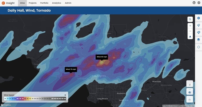
Powerful winds and dry conditions are contributing significantly to the situation. Wind gusts could be as high as 90 mph in certain areas (Figure 1), potentially marking the most severe conditions since a 2011 windstorm in Los Angeles County.
In addition to the Palisades Fire, other notable wildfires in the region include the Eaton Fire in Altadena, which has burned 2,227 acres and the Hurst Fire in Sylmar, which has burned 505 acres. Both fires also resulted in the evacuation of many neighborhoods.
These three active fires remain entirely uncontained. Numerous homes have already been destroyed, though exact numbers are still unavailable. Winds are expected to persist in the 30-50 mph range throughout the day, forcing the grounding of all tanker flights due to unsafe conditions. The fires continue to burn aggressively across all three areas, and forecasts are predicting single-digit relative humidity and strong winds, which will further fuel the flames.
Wildfire risk in the region
Cotality estimates that there are over 456,000 homes with nearly $300 billion in reconstruction cost value at moderate or greater risk within the Los Angeles and Riverside metropolitan areas.
It is important to note that this data represents the total number of homes and reconstruction cost value within the metropolitan areas at risk in general and is not specific to the current fire events. Data specific to the current fire events may be provided once there are well-defined fire perimeters.
The maps below show the wildfire risk in the areas of the three major fires in the region. Many properties are in the wildland-urban interface (WUI), which is an area where human development like homes and infrastructure meets or intermingles with natural, undeveloped wildland vegetation. This zone is particularly vulnerable to wildfires due to the proximity of flammable vegetation and human structures.

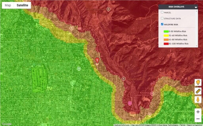
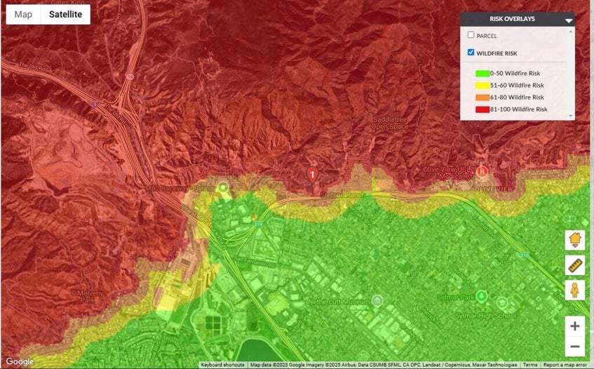
As urban expansion continues, the WUI zone grows. This increased intermingling of wildland and human development elevates the risk of fire-related disasters. Managing these areas requires a combination of fire-resistant building materials, defensible space around properties, and proactive land management practices to reduce fuel loads. Effective emergency planning, community education, and early detection systems are also critical in minimizing the impact of wildfires in these high-risk zones.
According to Cotality’s senior hazard scientist Dr. Tom Jeffery, the area of the Palisades Fire has been classified as abnormally dry since early December, and the area just transitioned to a moderate drought within the last 10 days.
“The area has been drying since the seasonal precipitation that occurred in late 2024,” explained Dr. Jeffery. “The Santa Ana winds that are currently driving these fires occur periodically, but the most recent winds are exceptionally strong, with reported speeds of 50 to 60 mph and greater. This not only drives the fires and embers but also inhibits flying the tanker aircraft and helicopters used to suppress the fires. There have been several small fires in this general area in the past: the 2019 Palisades Fire and the 2017 Topanga Fire. The 2021 Palisades Fire burned 1,203 acres but was located in an undeveloped area north of the Palisades community.”
The Cotality Hazard HQ Team will continue to monitor the Southern California fires. Updates, including the number of properties and reconstruction value within the fire perimeters and damage estimates, may be provided when the full extent of impact is more known.
.jpg)

